The risk of catastrophic wildfire is growing steadily. A newly updated online tool gives people a more detailed look at where risks are greatest – and what to do about them.
The U.S. Forest Service’s Wildfirerisk.org website first launched in 2020 with the goal to help leaders and residents of fire-threatened communities understand the danger they face – and take steps to reduce them. The tool was just updated with improved vegetation and weather data, as well as updated wildfire hazard modeling.
It now shows that roughly 115 million people – or one third the U.S. population – live in counties with high wildfire risk. More than 60% of counties in Washington and Oregon have such risk, up from 47%in past iterations. Kelly Pohl, the associate director of Headwaters Economics, which partnered with the Forest Service on the site, said risk is growing as the climate warms and dries, and more homes are built in the wildlands.
“The good news is that there are practical, proven steps we can take now to help safeguard communities,” she said. “And the website includes resources to help you take action.”
Among a number of features, users can see where at-risk structures are concentrated, get tips on making structures more fire-resilient, and research funding available for mitigation work.
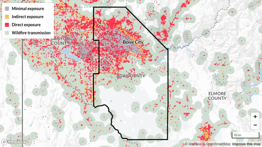
To illustrate the tool’s new ability to highlight areas of concern, she searched for Ada County, home to the Idaho capital Boise. The site shows that wildfire risk there is higher than 99% of U.S. counties, but that risk isn’t borne equally in the area. Data on the site show that nearly 60% of structures have minimal fire exposure, but 27% have direct exposure.

“Those are places where we might want to pay very close attention,” she said.
The site also provides data on vulnerable populations, like elderly residents and those without access to a vehicle or who speak limited English.
“This tool can really help leaders understand where neighborhoods might experience wildfires differently and anticipate those needs to help communities prepare ahead of time,” Pohl said.
This story was produced by the Mountain West News Bureau, a collaboration between Wyoming Public Media, Nevada Public Radio, Boise State Public Radio in Idaho, KUNR in Nevada, KUNC in Colorado and KANW in New Mexico, with support from affiliate stations across the region. Funding for the Mountain West News Bureau is provided in part by the Corporation for Public Broadcasting.


