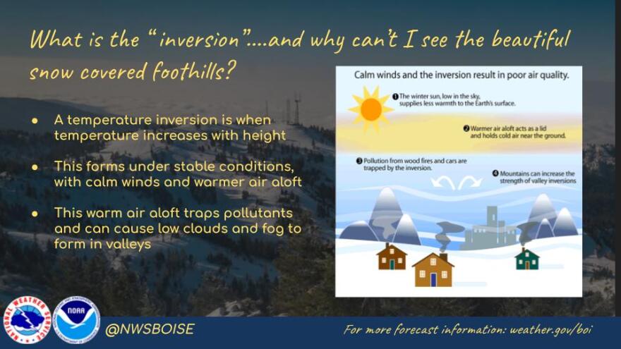
It happens every year in Boise and the Treasure Valley: Meteorologists and the National Weather Service Boise say an inversion is setting in and will be sticking around for at least a few days and everyone groans … but what exactly is an inversion?
The National Weather Service defines it as “a layer in the atmosphere in which air temperatures increase with height. An inversion is present in the lowest part of a cap.”
Simply put, an inversion is a weather event that occurs when a layer of warm air traps cooler air near the surface, leading to a stagnant air mass.

Why does it happen in the Treasure Valley
As far as the why when it comes to an inversion, the air near the ground cools more quickly than the air above it. Cooling will happen more often in low places, like valleys, and is more common in winter in the Treasure Valley when nights are long and the ground stays cooler for longer.
Effects on the weather
While getting above the inversion makes for good views, almost as if looking at an ocean of clouds, they are somewhat problematic. The air under an inversion has nowhere to go – picture a lid being screwed onto the valley.
Things like smoke and pollution get trapped, which often contribute to a decrease in air quality and associated side effects such as headaches and asthma. It’s not unusual for the Idaho Department of Environmental Quality to issue air quality advisories during inversions.

During an inversion, the weather will be cooler on the valley floor compared to higher in elevation. Surface-level dew or frost and fog are not uncommon because little to no evaporation can happen, according to North Dakota State University.
The wind also has an effect, but inversions are generally stable enough to resist movement when wind speeds are under 5 mph. As wind speeds increase, like those associated with cold fronts, it is more likely for an inversion to weaken and disappear.
How long does an inversion last?
The short answer is it depends. Some inversions can last in a period of a day to over a week, but the length is unpredictable and strongly depends on weather patterns. Inversions often break when a weather system or wind pattern comes along to mix the air layers – so keep an eye on the forecast.


